What You Miss When You Only Visit South Africa for Safari

Mapungubwe National Park, South Africa.

Mapungubwe National Park, South Africa.

In 2014, South Africa's heritage agency placed a sacred lake, one traditionally accessed only under local protocol, under national protection. Three stops beyond Kruger and the conventional wildlife circuit offer something different if you want an experience beyond the Big Five in South Africa.

What connects Kgalagadi, Mapungubwe, and Venda is what each reveals about a country whose international image has been built almost entirely around megafauna. Mapungubwe records a gold-trading kingdom with roots more than two centuries before European ships reached the southern African coast. Lake Fundudzi is a body of water whose custodians have spent decades regulating access. Kgalagadi is a desert where the animals that draw travelers survive by never needing what a savanna herd requires. None is more scenery layered on top of a safari. Each is a different answer to the same question: what does the safari lens cause a traveler to miss?

Extraordinary travel begins with the human touch and our destination specialists design every journey with meticulous care and attention to detail. No two Zicasso itineraries are the same because no two travelers are. Your specialist confirms the access, permissions, and guides these places require before you land, so the trip is spent inside the history and custom rather than arranging it.

Mapungubwe: The Kingdom Under the Safari Map

Man looking at the landscape of Mapungubwe, South Africa.

The Mapungubwe Cultural Landscape sits at the confluence of the Limpopo and Shashe rivers, inscribed as a UNESCO World Heritage Site in 2003. From roughly 1220 to 1290 CE, Mapungubwe was the seat of a stratified society and a working node in the Indian Ocean trade network, centuries before any European ship reached the southern African coast.

A King Moved to a Hill and Everything Changed

Around 1220 CE, during severe climatic drying, the ruling elite abandoned the adjacent settlement of K2 and relocated to the flat-topped summit of Mapungubwe Hill. An estimated commoner population of up to 5,000 people stayed on the plateau and valley floor below. The hill had long been used for rainmaking rituals and the move formalized something new: a king shielded from direct public view, communicating through intermediaries, whose authority rested on a claimed link to rain in an agrarian society facing drought.

Stone walling appeared as a visible marker of hierarchy, helping distinguish those who stood above others in a society of increasing social separation. The pattern would later find fuller expression at Great Zimbabwe and Thulamela.

The Site That Complicates the Official Story

Mapungubwe is widely presented as an early and influential center of stratified, sacral kingship in the region. Excavations at Mapela Hill, roughly 60 miles northwest in present-day Zimbabwe, complicate any claim that it was the sole origin point. Radiocarbon dating combined with Bayesian chronological modeling places prestige stone-walled terraces and elite dhaka floors at Mapela in the 11th century, well before Mapungubwe's peak.

The basal levels of those terraces contain early K2 pottery and glass beads, suggesting that sacral kingship in the Limpopo basin developed in more than one place rather than radiating outward from a single capital. Mapela is still largely absent from the public version of this history, a gap worth knowing before assuming Mapungubwe was first.

Gold That Was Never Meant to Leave the Ground

The wealth behind Mapungubwe's hierarchy came from controlling regional gold and ivory, exported north to the Swahili coast. The most recognized object recovered from the elite burials on Mapungubwe Hill is the Golden Rhinoceros: gold foil beaten over a carved wooden core and secured with minute gold tacks.

Gold cannot be radiocarbon dated directly, so researchers used Accelerator Mass Spectrometry on organic fibers entwined in gold and iron anklets found in the same graves. The work helped establish a 13th-century context for the objects, which are still among the oldest indigenous gold artifacts found in southern Africa.

Later trace-element analysis linked the gold to local alluvial deposits. The work also indicated that the copper content was likely a natural component of the mineral concentrate rather than an intentionally added alloy. Iconographic study of gold-foil fragments from the original burial suggests that the rhino, with a gold bovine and feline, may have been attached to a carved wooden divining bowl rather than displayed on their own, pointing to a cosmological system this landscape does not otherwise preserve in writing.

What the Beads Reveal About Who Was Trading With Whom

Glass beads arriving through the Indian Ocean network mark the kingdom's shifting trade partners with more precision than almost any other artifact. The Zhizo series, dating from the 8th through the mid-10th century, reflects early links to the Middle East before K2's rise. The K2 Indo-Pacific series, from the 10th to 12th century, marks a shift toward South Asian trade dominance.

Local craftspeople melted imported beads in clay molds to cast larger "garden-roller" beads of their own design, an indigenous technological adaptation rather than passive consumption. The 13th-century Mapungubwe Oblate series corresponds to the kingdom's peak wealth and its full integration into Swahili coastal trade. Fragments of Chinese Song dynasty celadon found on site confirm that Mapungubwe was linked to Eurasian and African trade cycles long before European maritime expansion reached southern Africa.

A Building Made From the Same Ground It Interprets

The Mapungubwe Interpretation Centre, designed by Peter Rich Architects, won World Building of the Year at the World Architecture Festival in Barcelona in 2009. Henry Fagan & Partners served as structural engineers, while John Ochsendorf and Michael Ramage contributed to the vault design.

Rather than imposing a concrete structure on a protected landscape, the architects used timbrel, or Catalan, vaulting, a centuries-old Mediterranean technique, to create wide, doubly curved, compression-only shells. Philippe Block checked the structural design using Thrust Network Analysis. The vaults were built from more than 200,000 stabilized earth tiles pressed on site from local soil mixed with five percent cement.

The low-carbon method doubled as a poverty-relief program, training local unemployed workers in tile pressing and masonry.

Visiting Mapungubwe

  • Access runs via the R572. Internal road conditions and vehicle requirements vary, particularly after rain, so confirm information directly with SANParks before travel.
  • Leokwe Rest Camp is the primary accommodation area. Confirm availability of accessible units and other facilities directly with SANParks when booking.
  • In late 2007, human remains excavated from Mapungubwe Hill in the 1930s were formally returned through a sequence of ceremonies. A symbolic handover took place at the University of Pretoria on October 29. The Freedom Park Trust and Limpopo provincial government hosted a cleansing ceremony on November 5, followed by a return-of-the-spirits ceremony on November 6. Reburials took place from November 18 to 20, with SANParks and archaeologists from the universities of Pretoria, Cape Town, and the Witwatersrand involved in the process.
  • Thulamela lies in northern Kruger near the Pafuri area. The drive from Mapungubwe requires route planning through Musina and toward Kruger's northern gates; travel time varies by route, gate, road conditions, and stops along the way.

Mapungubwe is one stop among many; see where it fits in Zicasso's 6 Best Places to Visit in South Africa.
Venda and Lake Fundudzi: The Lake That Refuses to Be a Destination

Where Mapungubwe is a curated, state-managed archaeological site, Lake Fundudzi is living heritage governed by customary law and local protocol. Widely described as one of South Africa's few natural inland lakes, it was formed when a massive landslide blocked the Mutale River.

A Lake With No Obvious Way Out

The lake receives water from the Mutale River and smaller tributaries, yet it has no obvious surface outlet. Water appears to seep through the landslide debris that formed the lake rather than leaving through a visible channel. Its sediment layers hold fossil pollen and other environmental evidence recording long-term changes in vegetation, fire history, and human activity.

That scientific record exists alongside another explanation, one held by the people who live around the water and have spent generations protecting it.

What the Water Answers To

For the Vhatavhatsindi clan, the lake's traditional custodians, hydrology is explained through cosmology and geology. Venda tradition holds that the lake formed after a passing leper, refused hospitality by a local village, cursed it, submerging the settlement beneath the water that rose in its place.

The lake is associated with ancestral spirits, a white crocodile, and a white python linked with fertility. The mood of the ancestors and the python is said to determine the color of the water and the timing of the seasonal rains. The lake anchors the Thevhula thanksgiving ritual and the Tshiswavhathu royal burial rites.

It sits within a wider sacred geography that includes Thathe Vondo Holy Forest, the burial ground of former chiefs, and Phiphidi Waterfalls. The Domba, or python, dance, performed by young initiates, and the Tshikona dance, played on traditional flutes at royal ceremonies and installations, draw on the spiritual authority of this landscape.

Approaching the Water

A visitor granted permission to see the lake may be asked to perform ukodola: turning away from the water, then bending forward to view it through spread legs. Protocols are determined locally and can vary by guide, community authority, site, and occasion. They should be followed as acts of respect, not treated as a photo opportunity.

The Clan That Keeps Saying No

Belief functions here as conservation policy. Local tradition holds that the lake rejects foreign objects, that water carried away from it will evaporate, and that an unauthorized approach may bring consequences. Those beliefs have helped keep the catchment largely free of mass tourism and development more effectively than a fence could.

The tension between protection and commercial pressure has played out in court. At nearby Phiphidi Waterfalls, the Ramunangi clan fought a prolonged legal battle to stop the development of a tourist resort and access road on land it considers sacred.

In 2014, the South African Heritage Resources Agency declared the Lake Fundudzi Cultural Landscape a National Heritage Site. The designation protects the cultural and spiritual significance of the site and places controls on development; it does not make all building automatically illegal across a fixed radius.

Visiting Lake Fundudzi

  • Access should be arranged through recognized local guides and with permission from the Netshiavha traditional leadership.
  • This is not a site for a casual stop. Independent, unguided visits are neither appropriate nor reliably available.
  • Photography and access protocols can shift by site and occasion. A specialist should confirm current restrictions before the visit rather than at the gate.

Pairing Venda with a northern Kruger safari? Start with How to Plan a Safari in South Africa: Frequently Asked Questions.

Kgalagadi: Wildlife That Was Never Meant to Be Abundant

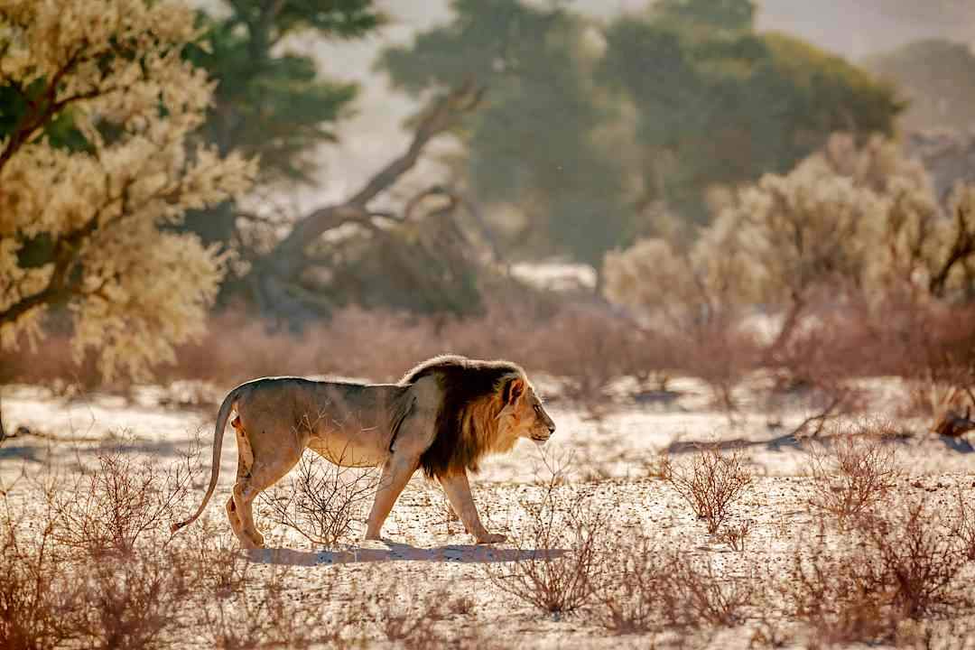
Lion sighting in the Kgalagadi Park, South Africa.

The Kgalagadi Transfrontier Park straddles the border with Botswana across roughly 14,700 square miles of the southern Kalahari. Temperatures can range from about 12°F to 113°F, annual rainfall is roughly six to 12 inches, and the landscape is built from parallel red sand dunes and the fossil riverbeds of the Auob and Nossob rivers.

Rivers That Rarely Flow

The Auob and Nossob are ephemeral river systems, their dry beds defining much of the park's ecology. The Nossob may carry surface water only after exceptional rain, while the Auob can flow more often. What sustains the ecosystem is the underground moisture that supports dense stands of camel thorn and shepherd's trees along the dry riverbeds.

Those beds function as linear oases and migration corridors, the reason herbivores and, in turn, predators concentrate along a line rather than spreading evenly across the desert.

An Antelope That Does Not Need to Drink

The gemsbok survives Kgalagadi's dry conditions by deriving much of its moisture from forage, including water-rich roots and tubers, and by feeding during cooler periods when plant moisture is highest. It is built for a landscape in which permanent surface water is not guaranteed.

Springbok take a different approach, moving through the wider Kalahari in response to rain and fresh grazing. Together, these herbivores form a crucial part of the prey base that shapes the park's predator ecology.

Lions Shaped by Scarcity

Kgalagadi's black-maned lions are among the park's most recognized animals. In a landscape where prey is scattered and water is scarce, they can hold far larger ranges than lions in denser savanna systems. Sightings here require patience, not because the park lacks wildlife, but because its animals live according to the scale and limits of the desert.

Raptors, including martial eagles and lappet-faced vultures, are equally important to the ecosystem. Their presence depends on a functioning transfrontier landscape, one in which wildlife and ecological processes move across the South Africa–Botswana border.

The Land Claim That Reshaped the Park

The Kgalagadi is also part of the ancestral landscape of the ǂKhomani San. A land claim resolved in 1999 restored rights to tracts of land within and adjacent to the park, leading to the !Ae!Hai Kalahari Heritage Park agreement in 2002. In 2017, the area was inscribed as the ǂKhomani Cultural Landscape World Heritage Site.

That heritage rests on tracking skill, landscape reading, and medicinal-plant knowledge developed across generations. It is documented in part through the Hugh Brody archive at the University of Cape Town, an ongoing effort to map traditional place names and pass ethnoecological knowledge from elders and master trackers to younger generations.

The tourism economy can too easily expect "authentic," untouched hunter-gatherers, flattening living expertise into spectacle. The ǂKhomani San navigate present-day economic marginalization as well as an encounter with visitors who may expect to see only a simplified version of the past.

Visiting Kgalagadi

  • Most visitors enter through Twee Rivieren. The approximately 155-mile drive from Upington to the gate is tarred.
  • Inside the park, roads are generally gravel and conditions can be demanding, particularly after weather changes.
  • A high-clearance vehicle or 4x4 is most useful for designated wilderness trails, some Botswana-side routes, and more difficult sand conditions. Confirm road conditions, border procedures, fuel availability, and vehicle requirements before departure.
  • The park rewards self-sufficiency. Distances between camps are long and travelers should plan around fuel, water, supplies, and road conditions rather than convenience.
  • Wildlife density reads differently here from Kruger. Fewer animals may be visible at any given moment; what is visible is adapted to survive without the water and grazing density a savanna guarantees.

For the desert-adapted species worth the drive, see Top 15 Animals of South Africa and Where to See Them.

Plan Your Journey Beyond the Safari

Kgalagadi Red dunes, South Africa.

These places don't fit into one itinerary and an honest trip plan says so up front. Mapungubwe and Venda form a workable northern Limpopo route, a few hours apart within the Vhembe Biosphere Reserve. Both connect onward to Kruger's northern gates. Kgalagadi stands alone: a dedicated expedition into the Northern Cape, best paired with Upington or the Cape rather than forced into the same trip as the other two.

What holds them together is not geography. Mapungubwe shows that the ground beneath a Kruger-bound traveler's itinerary once carried a gold-trading kingdom with global reach. Lake Fundudzi shows how a landscape can be protected through cultural authority and customary protocol, not simply a fence or park boundary. Kgalagadi demonstrates that wildlife does not require abundance to be worth watching, only the knowledge to understand how little the desert was ever built to hold. A safari answers what a traveler expects to see. These destinations answer what the safari never shares. For more on planning a trip that goes beyond the safari, explore Zicasso's South Africa Travel Guide and Southern Africa Safari Guide.

30,000+ Verified Traveler Reviews